The degree of corrosion of metal reinforcing is a major concern with bridge decks and similar concrete structures. Since the presence of saline water and corrosion by-products causes strong attenuation of GPR signals, measuring and mapping the variations in GPR signal attenuation has become an accepted practice to assess the condition of concrete structures.
Contact us today to learn how you can get unbeatable lease options on our full range of Ground Penetrating Radar equipment with low monthly payments!
NOGGIN®
Configurations
The configuration is the way the GPR sensor is moved across a surface to collect data.
NOGGIN® configurations are designed to meet diverse exploration needs by allowing you to take your GPR into every environment and terrain on Earth.
If you need to go somewhere unique, we will help you get there. Our custom engineering team will create a configuration to optimize deployment of your NOGGIN® in specialty situations.
The SmartCart® provides a self-contained, mobile platform for transporting the NOGGIN® and DVL for fast, efficient data acquisition over smooth to moderately rough terrain.
SmartCart® features:
A wheel odometer to trigger data acquisition at default or user-defined intervals (step size) to provide uniform data coverage.
A bi-directional odometer that triggers data acquisition in one direction and, in the other direction, provides a back-up arrow to easily pinpoint the location of objects found on the survey line.
GPRLine’s unique DynaQ® feature automatically adjusts data acquisition rates to the survey speed; providing dynamic stacking to maximize data quality.
Options::
GPS to provide geo-referenced coordinates linked to the data
Brackets to quickly swap between the NOGGIN® 100, 250, 500 and 1000 sensors
Supported Sensors:
The SmartCart™ supports all NOGGIN® sensors.
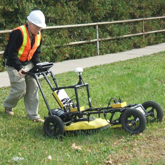
SmartTow™
Mode of Operation
The NOGGIN® SmartTow™ configuration is designed for hand-tow surveying over smooth to rough terrain such as grassy, brush covered or rocky surfaces. But don’t worry about damaging your NOGGIN® by dragging it around on rough surfaces – all Noggins have a durable skid plate on the bottom to smoothly slide across any surface and maintain ground-coupling for maximum signal penetration.
SmartTow™ features:
A wheel odometer to trigger data acquisition at default or user-defined intervals (step size) to provide uniform data coverage.
A bi-directional odometer that triggers data acquisition in one direction and, in the other direction, provides a back-up arrow to easily pinpoint the location of objects found on the survey line.
GPRLine’s unique DynaQ® feature automatically adjusts data acquisition rates to the survey speed; providing dynamic stacking to maximize data quality.
Options::
GPS to provide geo-referenced coordinates linked to the data.
Longer cables to enable the DVL to be set in a fixed position while the GPR sensor is moved.
Batteries of different sizes and capacities depending on field time or portability requirements.
Brackets to quickly swap between the NOGGIN® 100, 250, 500 and 1000 systems.
Supported Sensors:
The SmartTow™ supports all NOGGIN® sensors.
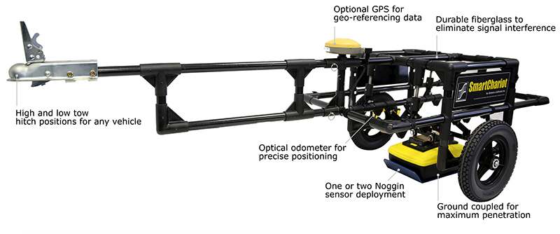
SmartChariot™
Mode of Operation
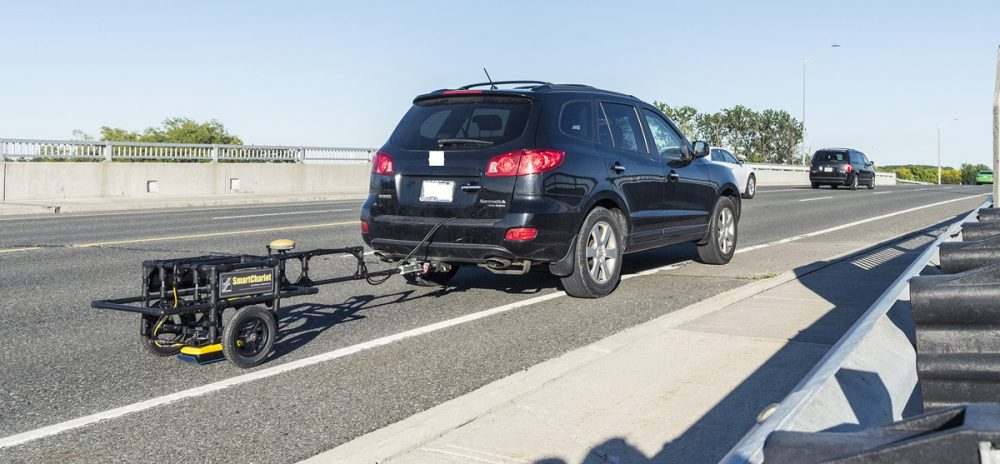
The SmartChariot™ provides vehicle-towed deployment of NOGGIN® 250, 500 or 1000 systems. It is ideal for surveys covering large, smooth, open areas that can be performed using a vehicle: roads, highway sections and bridges needing quick assessment, large parking lots, parking garages, and open fields such as golf courses and parks. The SmartChariot™ attaches to a common trailer hitch on any vehicle: cars, trucks and vans, but also ATV’s (all-terrain vehicles), tractors and even bicycles and motorcycles can be used.
SmartChariot™ features:
A wheel odometer to trigger data acquisition at default or user-defined intervals (step size) to provide uniform data coverage.
GPRLine’s unique DynaQ® feature automatically adjusts data acquisition rates to the survey speed; providing dynamic stacking to maximize data quality.
A mount for a GPS receiver (GPS optional).
Brackets to quickly swap between the NOGGIN® 250, 500 and 1000 systems.
The ability to deploy two Noggins simultaneously: a NOGGIN® 500 and a NOGGIN® 1000.
Options:
The following optional items are available to customize the system for your needs.
GPS to provide geo-referenced coordinates linked to the data.
Smaller or longer-life batteries depending on the time duration of measurements or portability requirements.
Supported Sensors:
The SmartChariot™ supports the NOGGIN® 250, 500 or 1000 sensors.
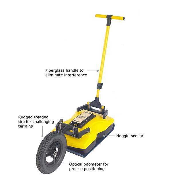
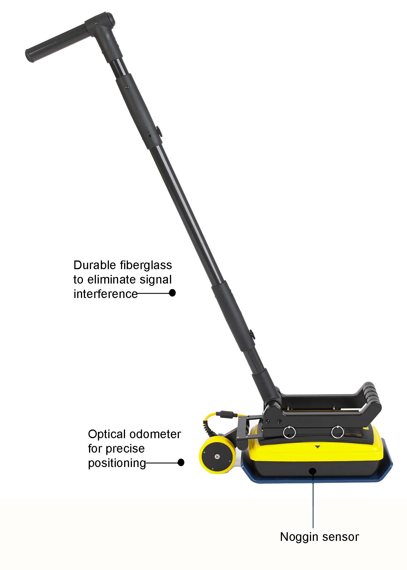
SmartHandle™
Mode of Operation:
The NOGGIN® SmartHandle™ configuration is designed for pushing or pulling the NOGGIN® over smooth terrain. Light and compact, the SmartHandle™ is the ideal configuration for vertical or overhead surveys, or surveys in confined spaces.
SmartHandle™ features:
A small wheel odometer to trigger data acquisition at default or user-defined intervals (step size) to provide uniform data coverage.
A bi-directional odometer that triggers data acquisition in one direction and, in the other direction, provides a back-up arrow to easily pinpoint the location of objects found on the survey line.
GPRLine’s unique DynaQ® feature automatically adjusts data acquisition rates to the survey speed; providing dynamic stacking to maximize data quality.
A 2 piece handle that can be assembled to full length handle (0.9m, 35”) or a shorter handle (0.4m, 16”).
Options:
GPS to provide geo-referenced coordinates linked to the data.
Brackets to quickly swap between the NOGGIN® 500 and NOGGIN® 1000 sensors.
Supported Sensors:
product.smarthandle_supported_sensors
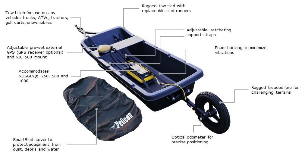
SmartSled
Modes of Operation
The NOGGIN® SmartSled configuration is designed for vehicle-towed surveying for NOGGIN® 250, 500, and 1000 GPR systems over smooth to rough, open terrain such as agricultural fields, grass, gravel roads or rocky surfaces. The SmartSled attaches to a common trailer hitch on any vehicles such as trucks, ATVs, tractors, golf carts, or snowmobiles. Designed to deploy your NOGGIN® on various terrains, the SmartSled has built-in straps to secure the sensors and maintain ground-coupling for maximum signal penetration.
SmartSled Features
A wheel odometer to trigger data acquisition at default or user-defined intervals (step size) to provide uniform data coverage.
Sensors & Software’s unique DynaQ® feature automatically adjusts data acquisition rates to the survey speed; providing dynamic stacking to maximize data quality.
Adjustable mount for a GPS receiver (GPS optional) and NIC-500N for SPIDAR.
When coupled with an external GPS, the SmartSled can collect large GPR pseudo-grid surveys that can be processed into depth slices using the EKKO_Project software module called SliceView Lines.
Adjustable straps to quickly swap between NOGGIN® 250, 500 and 1000 systems.
Options:
GPS to provide geo-referenced coordinates linked to the data.
Varying cable lengths depending on your requirements.
Batteries of different sizes and capacities depending on field time or portability requirements.
Supported Sensors:
The SmartSled supports the NOGGIN® 250, 500 or 1000 transducers.
SPIDAR® & Custom Configurations
NOGGIN® 250 and 500 SPIDAR® Cart configuration
Mode of Operation:
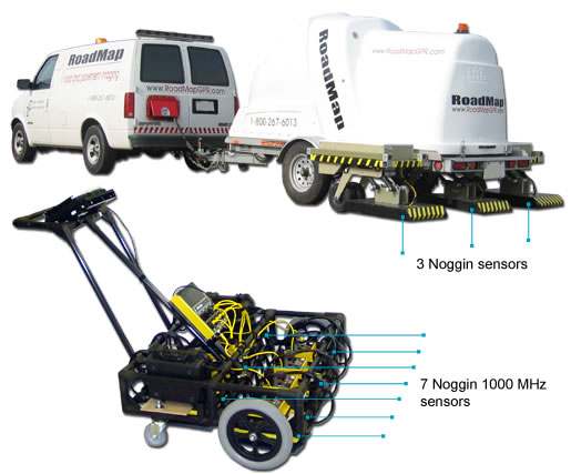
For applications that require large area coverage or multi-frequency concurrent data collection, two or more NOGGIN® systems can be networked together into a multi-channel GPR called a SPIDAR® system. From towing several units behind an ATV, to deploying a NOGGIN® 1000 on a retractable arm on a mining machine, to deploying an array of Noggins on a sewer inspection platform, our custom engineering team can help you design a configuration best suited to your unique operational needs.
Options:
SPIDAR® NICs and SpiView data acquisition software
A wide range of ancillary handles, odometers, control system housing and cables
Custom carts and mounting brackets
Wireless network support for multi-frequency arrays
GPS to provide geo-referenced coordinates linked to the data
Batteries of different sizes and capacities depending on field time or portability requirements